Real World Math
  • Home
  • Lesson Downloads
    • Concept Lessons
    • Measurement Lessons
    • Project Based Learning
    • Exploratory Lessons
    • Space Lessons
  • Videos
  • Tutorials
    • Google Earth Tutorials
    • Xtranormal Tutorials
    • HTML Layout Tutorials >
      • Introduction
      • The Basics
      • Layout Templates >
        • Cover page
        • Blogger HTML Formatting
        • Paragraphs w Image
        • Image w. bullets
        • Video
        • Split text & image
        • Complex table
      • More tips
  • Teachers
    • Lessons >
      • Concept Lesson Outlines >
        • Around the World...
        • Estimation
        • Exchange Rate
        • Line Graphs
        • Oil Spill Estimates
        • Planes of Greenland
        • Polyhedrons
        • Scientific Notation 1
        • Scientific Notation 2
        • Tessellations
        • Time Zone Problems
        • Volume of Solids
      • Measurement Lesson Outlines >
        • Intercept Theorem
        • Complex Area
        • Crop Circles
        • Estimating Distance
        • Fractal Coastline
        • Tsunami Warning
      • PBL Lesson Outlines >
        • Spreadsheet App
        • Community Building
        • Iditarod Challenge
        • SAR Project
        • SketchUp
        • Typhoon Project
        • U-Boat Hunt
        • Water Problems
      • Exploratory Lesson Outlines >
        • Crop Circles 2
        • Four Color Map
        • Line Patterns
        • Mazes & Labyrinths
        • Networks
        • Pyramid in the Desert
        • The Flat Earth
        • Whale Watch
      • Space Lesson Outlines >
        • Lunar Fieldtrip
        • Lunar Sports
        • Rockets
    • Blog
    • About the site
    • RWM Video Overview
  • Contact
Kmz Download

Teacher Downloads


No additional downloads

Concepts Used
Geometry
Spatial Reasoning
Inductive Reasoning

Grade level
Grades 5-10

Subject Areas
Math

NCTM Standards
Geometry
Reasoning and Proof
Representation
Technology

NETS*S
1c, 6b, 6d

3 plane interesections
Click to view

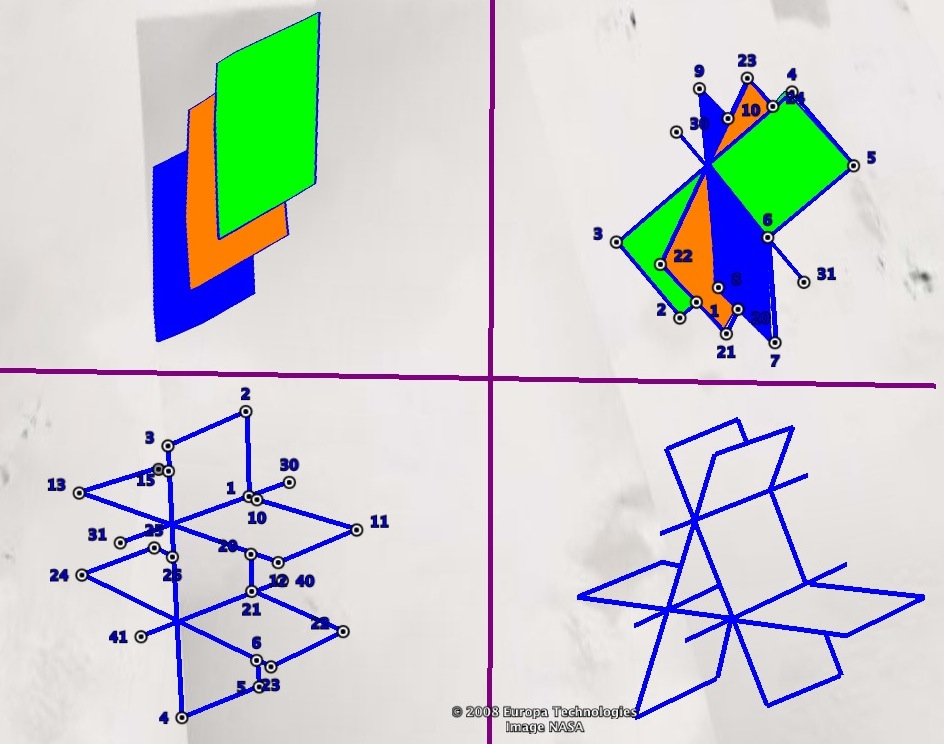
The Planes of Greenland


Objectives
  • Use the path tool to create lines in Google Earth
  • Modify the path tool's settings
  • Analyze the possibilities of 3 lines intersecting
  • Draw models of 3 planes intersecting

Lesson Description

The primary goal of this lesson is to teach students how to use the Path tool in Google Earth.  This tool is used in many of the lessons on this website and so knowing how to draw paths and edit their appearance is important.  For this activity they will need to be able to set the path’s width and modify the color.  For assistance on how to use the Path tool in Google Earth, view or download the Adding a Path tutorial video or follow this link.

The math content of this activity is a geometry exercise that involves logic.  To begin make sure the students understand the concept of intersection.  Start with two lines that intersect and two that are parallel.  Next, ask the students to consider the possibilities involved with three lines.  What are all of the ways three lines can intersect? ( 0,1,2, and 3 points )

Review the concept of “planes” and have the students consider how two planes can intersect.  On the board or overhead, draw two planes that are parallel and two that intersect in a line.  Ask the students to consider three planes and the different ways they can intersect.  You may want to have them write or draw their predictions.  Don’t reveal the answer for them - assign the Planes of Greenland and let them discover on their own.

There are several possible follow-ups for this activity.  One is to introduce the polygon tool in Google Earth and ask the students to color their drawings.  They will need to be able to modify the polygon color settings.  Have them try to avoid overlapping polygons by manipulation or by drawing several polygons.  The other follow-up is to have the students draw the four diagrams with paper and pencil.
Powered by Create your own unique website with customizable templates.