Real World Math
  • Home
  • Lesson Downloads
    • Concept Lessons
    • Measurement Lessons
    • Project Based Learning
    • Exploratory Lessons
    • Space Lessons
  • Videos
  • Tutorials
    • Google Earth Tutorials
    • Xtranormal Tutorials
    • HTML Layout Tutorials >
      • Introduction
      • The Basics
      • Layout Templates >
        • Cover page
        • Blogger HTML Formatting
        • Paragraphs w Image
        • Image w. bullets
        • Video
        • Split text & image
        • Complex table
      • More tips
  • Teachers
    • Lessons >
      • Concept Lesson Outlines >
        • Around the World...
        • Estimation
        • Exchange Rate
        • Line Graphs
        • Oil Spill Estimates
        • Planes of Greenland
        • Polyhedrons
        • Scientific Notation 1
        • Scientific Notation 2
        • Tessellations
        • Time Zone Problems
        • Volume of Solids
      • Measurement Lesson Outlines >
        • Intercept Theorem
        • Complex Area
        • Crop Circles
        • Estimating Distance
        • Fractal Coastline
        • Tsunami Warning
      • PBL Lesson Outlines >
        • Spreadsheet App
        • Community Building
        • Iditarod Challenge
        • SAR Project
        • SketchUp
        • Typhoon Project
        • U-Boat Hunt
        • Water Problems
      • Exploratory Lesson Outlines >
        • Crop Circles 2
        • Four Color Map
        • Line Patterns
        • Mazes & Labyrinths
        • Networks
        • Pyramid in the Desert
        • The Flat Earth
        • Whale Watch
      • Space Lesson Outlines >
        • Lunar Fieldtrip
        • Lunar Sports
        • Rockets
    • Blog
    • About the site
    • RWM Video Overview
  • Contact
Kmz Download
Teacher Downloads

Student Activity Sheet
Student Log Sheet
Tsunami Rubric


Concepts Used
Measurement
24 Hour Clock
Elapsed Time
Rate
Distance Formula

Grade level
Grades 6-9

Subject Areas
Math
Geography
Science

NCTM Standards
Measurement
Data Analysis
Connections
Representation
Technology

NETS*S
1a, 1c, 1d, 3a, 3b, 3c,
3d, 4a, 4c, 4d, 6b

Tsunami Warning


Objectives
  • Measure the distance tsunami waves traveled to 18 locations
  • Figure the elapsed time for the waves to travel
  • Calculate the speed tsunami waves traveled
  • Compare wave speeds and make conjectures

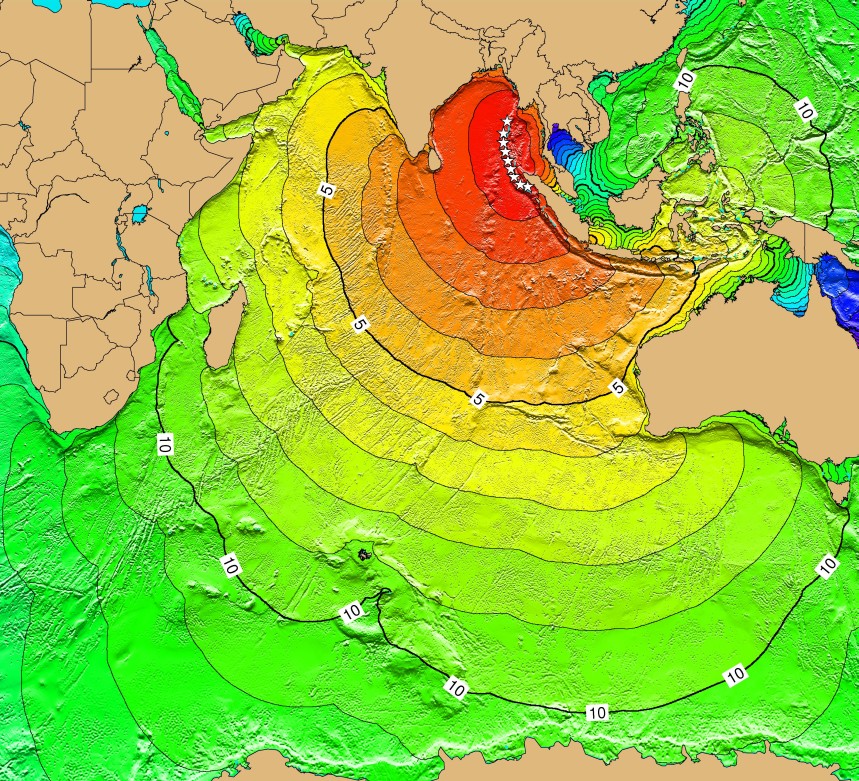
Lesson Description

The 2004 Indian Ocean tsunami touched virtually every ocean shoreline on the planet.  In this activity the students will calculate the speeds these killer waves took across the ocean using Google Earth.  Included in the file is a tour of 33 locations affected by the tsunami with descriptions.  The students will use the Google Earth ruler tool to measure the distance to 18 of these locations and calculate the rate the waves traveled to each.

They'll find the waves traveled at different speeds in different directions.  Waves were hitting Sri Lanka before reaching Thailand even though it is much closer geographically. 
This is a good example that numbers do not always behave in the real world as we may expect them to.  Discussions and investigations should follow as to why this was, preferably instigated by the students.

Cross-curricular explorations in Science and Geography is highly recommended for this activity.


Note:  Many helpful links are contained on the last two placemarks: Credit and Images.
  The NOAA site for educators is a valuable resource.

Wave Rate Overlay

I'm including the Kmz file for this image overlay below.  You can edit the image in Google Earth and adjust the transparency.  This image file is something I wouldn't share with students until the end because I would want them to make these discoveries on their own.  The end of the activity might be a good time for you to use this, to help sum up the activity. (Image credit retrieved from this site.)
Kmz download
Picture
Powered by Create your own unique website with customizable templates.