|
Teacher Downloads
SAR Assignment Sheet
SAR Presentation SAR Group Wiki SAR Rubric Drift path of missing paddler Sample student work
|
Search and Rescue Project
Objectives
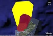
Lesson Description This lesson simulates a Search And Rescue (SAR) operation at sea in which the students are members of the Coast Guard. Working in teams, they must decide how to conduct their search using the equipment and data available to them. Lesson components include actual search patterns used in this kind of operation and vehicle specifications for a helicopter and cutter. The main idea that this activity reinforces is that most problems involve variables. In this scenario, variables such as wind, time, rate, current, and so on play a major part in how the problem should be addressed. You should spend time emphasizing how variables exist in real world problems as opposed to the abstract versions found in textbooks. As a Project Based Learning exercise, the activity should last several days and the teacher should act as a facilitator to the students. Encourage plenty of discussion that leads students to the desired results. “Someone is missing. Where do you look first?”, “What kind of information do you need to know?”, “What equipment do you need?”, “Are there any limitations?” etc. Students could be asked to keep a journal of their decision making process. The SAR Group Wiki (available with the Teacher Downloads) is a Doc I’ve used for this in the past. Make a copy for each group and guide them through the assignment with it. A Powerpoint presentation is also available with the Teacher Downloads. The powerpoint includes search pattern information and search vehicle specifications. Students could be asked to research or design their own search patterns. Provide students with the SAR Google Earth file which includes the search region. The students need to map their search patterns on Google Earth using the path tool. With the ruler tool and information on the speed of SAR vehicles, the students should calculate and include placemarks for the times of major turns or in 30 minute intervals. Successful SAR operations will consider spotting distance, environmental conditions, vehicle speed, and search pattern design. The path of the missing person is an additional Google Earth file that should not be shared with the students until they have completed mapping their search patterns. With this component, they will be able to tell if their rescue efforts were successful or not. The students will need to make more measurements and calculations to determine if the missing person was spotted and when. Be sure to review the spotting distance information for each search vehicle. Success depends on the missing person being in sight of a SAR vehicle within the spotting distance. Helpful Links: |

|
|
